The space exploration landscape witnessed a historic moment on July 30, 2025, when the NASA-ISRO Synthetic Aperture Radar (NISAR) satellite successfully lifted off from India’s Satish Dhawan Space Centre in Sriharikota. This groundbreaking mission represents more than just another satellite launch—it’s a testament to international cooperation and the shared vision of understanding our planet better.
Let’s explore the NISAR satellite launch!
Understanding the NISAR Satellite Mission: More Than Just a Satellite
The NISAR mission stands as the first joint Earth observation satellite developed collaboratively by the Indian Space Research Organisation (ISRO) and NASA. What makes this mission particularly fascinating is its unique dual-band synthetic aperture radar system, combining L-band and S-band frequencies to provide unprecedented insights into Earth’s changing dynamics.
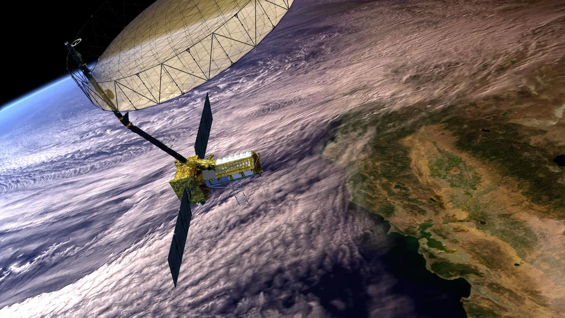
Weighing approximately 2,393 kilograms, this sophisticated observatory was launched aboard the GSLV-F16 rocket at precisely 5:40 PM IST. The satellite now orbits Earth at an altitude of 747 kilometers in a sun-synchronous polar orbit, positioned to capture comprehensive data about our planet every 12 days.
The Science Behind NISAR’s Revolutionary Technology
The heart of NISAR lies in its advanced radar technology. Unlike traditional optical satellites that depend on sunlight and clear weather conditions, NISAR’s synthetic aperture radar can penetrate clouds and operate day and night. This capability ensures continuous monitoring regardless of weather conditions—a crucial advantage for time-sensitive applications like disaster management and climate monitoring.
The satellite’s most striking feature is its massive 12-meter diameter reflector antenna, deployed 9 meters away from the main spacecraft using a complex deployable boom system designed by NASA’s Jet Propulsion Laboratory. This engineering marvel enables NISAR to achieve a remarkable 240-kilometer observable swath with resolution capabilities ranging from 5 to 100 meters.
Real-World Applications That Matter
NISAR’s impact extends far beyond scientific curiosity. The mission addresses critical global challenges that affect millions of lives worldwide. Scientists and researchers will use NISAR data to monitor deforestation patterns, track agricultural crop changes, and assess wetland health—information vital for food security and environmental conservation.
The satellite’s ability to measure ground deformation with millimeter precision makes it invaluable for earthquake monitoring and volcanic activity assessment. In regions prone to landslides or ground subsidence, NISAR data will provide early warning systems that could save countless lives and protect infrastructure investments.
Climate researchers are particularly excited about NISAR’s capability to monitor ice sheet dynamics in Greenland and Antarctica. As global temperatures rise, understanding how these massive ice formations respond becomes crucial for predicting sea level changes and their potential impact on coastal communities worldwide.
A Decade-Long Journey of International Collaboration
The path to NISAR’s successful launch wasn’t accomplished overnight. This ambitious project required nearly a decade of intensive collaboration between two of the world’s leading space agencies. The development process showcased how international partnerships can leverage each nation’s strengths to achieve common goals.
ISRO contributed the spacecraft structure, S-band radar system, launch vehicle, and satellite operations expertise, while NASA provided the L-band radar system, large reflector antenna, solid-state data recorder, and orbital planning capabilities. This division of responsibilities allowed both agencies to focus on their areas of expertise while learning from each other’s approaches.
The mission’s free and open data policy represents another significant aspect of this collaboration. Unlike many commercial satellite programs, NISAR data will be freely available to researchers, governments, and organizations worldwide, democratizing access to high-quality Earth observation information.
Looking Ahead: The Next Five Years
With a planned mission life of five years, NISAR is expected to revolutionize our understanding of Earth’s dynamic processes. The initial 90-day commissioning phase will focus on calibrating instruments and ensuring all systems operate optimally. Following this period, the science operations phase will begin, generating vast amounts of data daily.
The global scientific community eagerly anticipates the wealth of information NISAR will provide. Disaster management agencies will gain new tools for rapid response planning, while agricultural organizations can make more informed decisions about crop management and food security planning.
Environmental researchers will benefit from NISAR’s ability to track ecosystem changes over time, providing insights into how different regions respond to climate change. This information proves invaluable for developing adaptation strategies and conservation efforts.
Strengthening India-US Strategic Partnership
Beyond its scientific objectives, NISAR represents a significant milestone in India-US strategic partnership. As Science and Technology Minister Jitendra Singh noted, this mission embodies India’s vision of becoming a “Vishwa Bandhu” or global partner contributing to humanity’s collective welfare.
The successful collaboration demonstrates how democratic nations can work together to address global challenges through scientific cooperation. This partnership model could serve as a template for future international space missions, particularly as space exploration becomes increasingly important for addressing climate change, resource management, and global security concerns.
Global Impact and Future Possibilities
NISAR’s influence extends beyond the immediate scientific applications. The mission showcases India’s growing capabilities in space technology and reinforces the country’s position as a reliable international partner for complex space missions. For the United States, the collaboration provides access to India’s cost-effective launch capabilities and growing space expertise.
The success of NISAR paves the way for future collaborative missions between the two nations. As both countries continue developing their space programs, this partnership could expand to include lunar exploration, Mars missions, and other deep space endeavors.
The mission also highlights the importance of space-based Earth observation in addressing 21st-century challenges. As climate change, urbanization, and resource scarcity become increasingly pressing issues, missions like NISAR provide the data and insights necessary for informed decision-making at local, national, and global levels.
Conclusion
The successful launch of NISAR marks the beginning of a new chapter in international space cooperation and Earth observation capabilities. This mission demonstrates what becomes possible when nations combine their expertise, resources, and vision to tackle common challenges.
Over the next five years, NISAR will provide unprecedented insights into our planet’s changing landscape, helping scientists, policymakers, and communities better understand and respond to environmental changes. More importantly, it establishes a framework for future international collaborations that could help humanity address the complex challenges of the modern world through the power of space technology and scientific cooperation.